Extending an existing editing tool
1 Introduction
I got a question how an existing editing
tool could be used for another type of geometric operation. In a previous
document I showed how the use of the ‘cut’ method of the ArcGIS geometry
service can be used to split a geometry into different parts. The tool consists
of selecting a geometry and using a
polyline drawn. A split operation can be initiated through a REST call to the
ArcGIS geometry service with the two geometries or collection of geometries.
In this document I will explain how you can
use the ‘cut’ method of the ArcGIS geometry service to do a similar operation
but using a polygon instead of a polyline. You could consider this tool as a
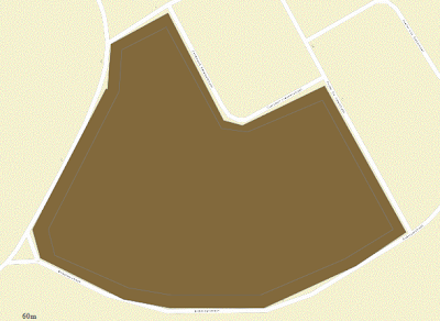
kind of punch tool for a geometry. Below is the illustration of the different
steps involved in the special split command. I start with a geometry shown
below:

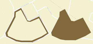
After a polygon has been drawn inside the geometry to be split, the result is shown below:
The two polygons looks like this:
2 Using the ‘cut’ method
Given the polygon as input, I want to use
to border line of the polygon for cutting a geometry out of the selected
polygon. In the tool described hereafter I assumed that the polygon has a
simple structure consisting of one solid block.
In the ArcGIS JavaScript API you can see
that a polygon consists of an array of rings. A ring consists of an array of
points. If we are looking at a polyline, you can see that a polyline consists
of an array of paths. A path consists of an array of points. So the common data
structure of polyline and polygon is that both consists of arrays of points.
What we basically must do is converting the polygon drawn into a polyline. This
can simply done by creating an empty polyline and adding a path consisting of
the array of points of the first ring of the polygon.
var polyline = new esri.geometry.Polyline(polygon.spatialReference);
polyline.addPath(polygon.rings[0]);
And as in the split command, do a REST call
to the cut command of the ArcGIS geometry service by using the previous defined
split function based on a polyline and a set of polygons.
this.splitOperation(featureLayer, selectGraphics, polyline,
geometryServiceComplete, geometryServiceFailed);
3 Conclusion
In ArcGIS desktop you can use built-in
tools and commands to write extensions on ArcGIS desktop to create more powerful tools and commands.
This makes it for the user easier to do editing on geometries by using this
custom tools and commands.
For web editing you can do exactly the same
thing. For web, the built-in tools are the different geometry tools available
in the ArcGIS geometry service. You can also create new tools on the server